
Surfing and Hiking in New Zealand
I’d spent most of the week looking at swell charts and surf forecasts. Hawaii looked like it was in a summer lull. Most of the Australian coast was going to be either too big and messy with that system destined to make Cloudbreak epic. The West coast of New Zealand was forecasted to suffer from massive, messy waves for the same reason.
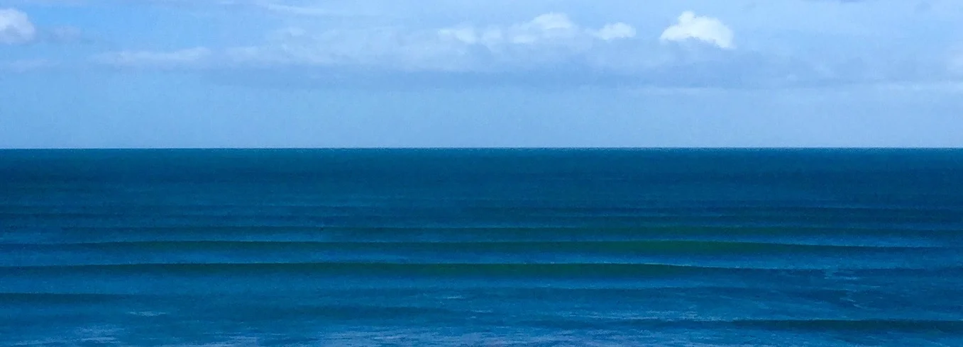
Gisborne, New Zealand looked like it was going to be perfect: 4-7 foot, 14 second period, light offshore winds.
I booked a flight at 6pm on a Friday. 24 hours later I was in Auckland having a beer with Johannes.
2 days after that i pulled up to the Air BnB I’d rented in Gisborne. It was already dark out, and the owner of the house was outside to wave me into the driveway.
“I see you’ve got your board with you,” he said when I started unpacking the car.
“Yeah, man. I’ve heard good things about the waves here,” I told him. Each of us knew that the other had that stoke for waves.
“Right in front of the house, you’ve got Pines. It’s hollow and heavy. It breaks boards and it breaks necks.,” He said, watching me unload my bags and board. “You got the beach in town. It’s good on the right swell. And you got Marakori point up the road. Just over the headland. If it’s big, it’s a good. If it’s windy in town, it’s good up there. It’s pretty much always good on the right swell. Hit it on the low tide coming up to high and you can’t go wrong.”
That was pretty much the only conversation I had with him the entire time I stayed there. It was also all I needed.
The next morning I was up at 5am, and could hear the waves crashing across the road. First light wasn’t until 630, and sunrise around 7, so I had time to organise things. I popped the fins into my board - going with the quad set-up. I took a look a my new wetsuit, a Vissla 4:3. I opened up my new wax and smelled it.
Then I loaded up the car, and headed up the coast. It was still too dark to really see the waves across the road as I drove up to the headland, but there was a feel of waves in the air, you know?

I pulled up to the gravel parking lot at Makorori a few minutes later. The AirBnB guy was right - it was perfect conditions. The sun was just barely coming up, and there were lines all the way to the horizon.
What followed was three amazing days of surfing: glassy conditions, with beautiful perfect turquoise waves rolling in on sets of three all day long and shifting enough with the tides to keep it interesting. I caught massive lefts. I threw big turns on some rights. I laughed. I got called into waves, and paddled back out to have the other guys in the line-up tell me I’d just caught a bomb. I paddled until my shoulders ached, then I went in for lunch, and went out again in the afternoon.
After three days of that, the winds shifted and the swell died, so I decided to go on a hike.
Mount Hikurangi looked promising: The tallest non-volcanic peak on the North Island, it’s also apparently the first place to see the sunrise in New Zealand, and it was only a two hour drive from where I was staying.
The recommended approach was to start in mid-morning, and hike the 10km to a hut, and to then wake up when it was still dark out the next morning to hike the 2.5km to the summit and watch the sun rise from there, taking the day to hike back to the parking lot. I didn’t have camping gear, and figured that 25km round trip was totally doable in a day. I wouldn’t see the sunrise, but it’s about the journey not the destination, right?
I left the place I was staying, and spent two hours driving down dark roads with logging trucks as my only companion on the road. The final few kilometres of the drive were dirt road and single-lane wooden bridges with planks missing, cold-looking rapids beneath them. The water was that kind of blue that looks like the blue millk they drink in Star Wars - you just know it’s come from further up in the mountains and that you don’t want to fall in.
I arrived at the grass parking lot for the hike and looked at the sign and map while I got my stuff together.
PARKING LOT TO HUT: 10km approx 4 to 7 hours
HUT TO SUMMIT: 2.5km approx 1 hour 30 minutes
Twenty-five kilometres round trip. It wasn’t going to be easy, but it was only just a little after 7am and I had about 10 hours of daylight to do it in. My plan was to finish in 6, which gave me plenty of buffer.
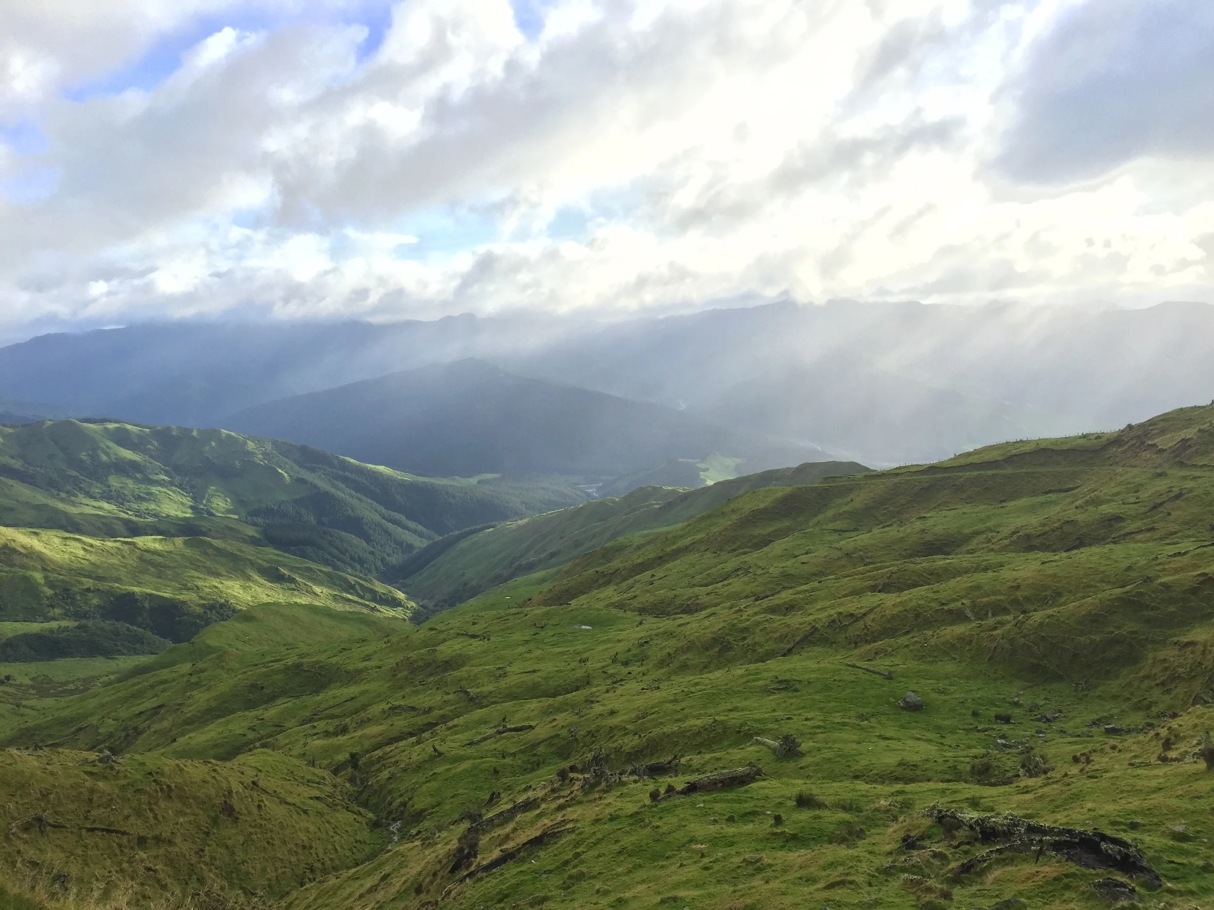
The walk to the hut was easy and breezy, just a dirt road that occasionally turned to soft grass and sheep shit through a farm. It wound up and down and over some ridges, but was generally even walk with a great view looking back out over where I’d come from.
I also made good time: a little under two hours to get to the hut, the 10km mark. I was sweating when I sat down to for a snack of raisins, peanuts, protein drink, an apple and some water. A sign near the hut told me that the last 400m of the trail were unmarked, and that alpine conditions were to be expected past this point.
Chilled by the wind blowing down from the mountain and realistic about what I might find past the hut, I layered up. Nike running tights. Kathmandu sweater. North Face rain jacket. Bargain bin toque. Kathmandu gloves. Oakley shorts overtop of the running tights (I know, right? Who even knew that Oakley made shorts? I bought them when I bought my new wetsuit because they were on sale, and because they looked sweet. I wore them because I always feel weird wearing running tights without anything over top. Even when I’m hiking by myself. Plus it’s always great to have pockets to put stuff in.)
Despite the layers, I was still a bit cold as I followed the trail, now noticeably steeper. So steep that I was barely leaning over, yet still using my hands to support myself. I stopped at every trailer marker. I was breathing heavily, and looking back. After about 500m of this, the trail came over a ridge and took me into rainforest-like conditions. There were massive ferns. Rotting logs. The air was misty, and I could see through to where the trail led and that fog was rolling in.
I came out of the forested area, and into a more alpine environment of short, spiky bushes and almost cactus-like plants. The trail markers were a bit farther apart at this point, and just when I thought I’d lost the path the next one would emerge from the mist.
Eventually, I couldn’t find the next one and since the only way to go seemed to be up, up I went.
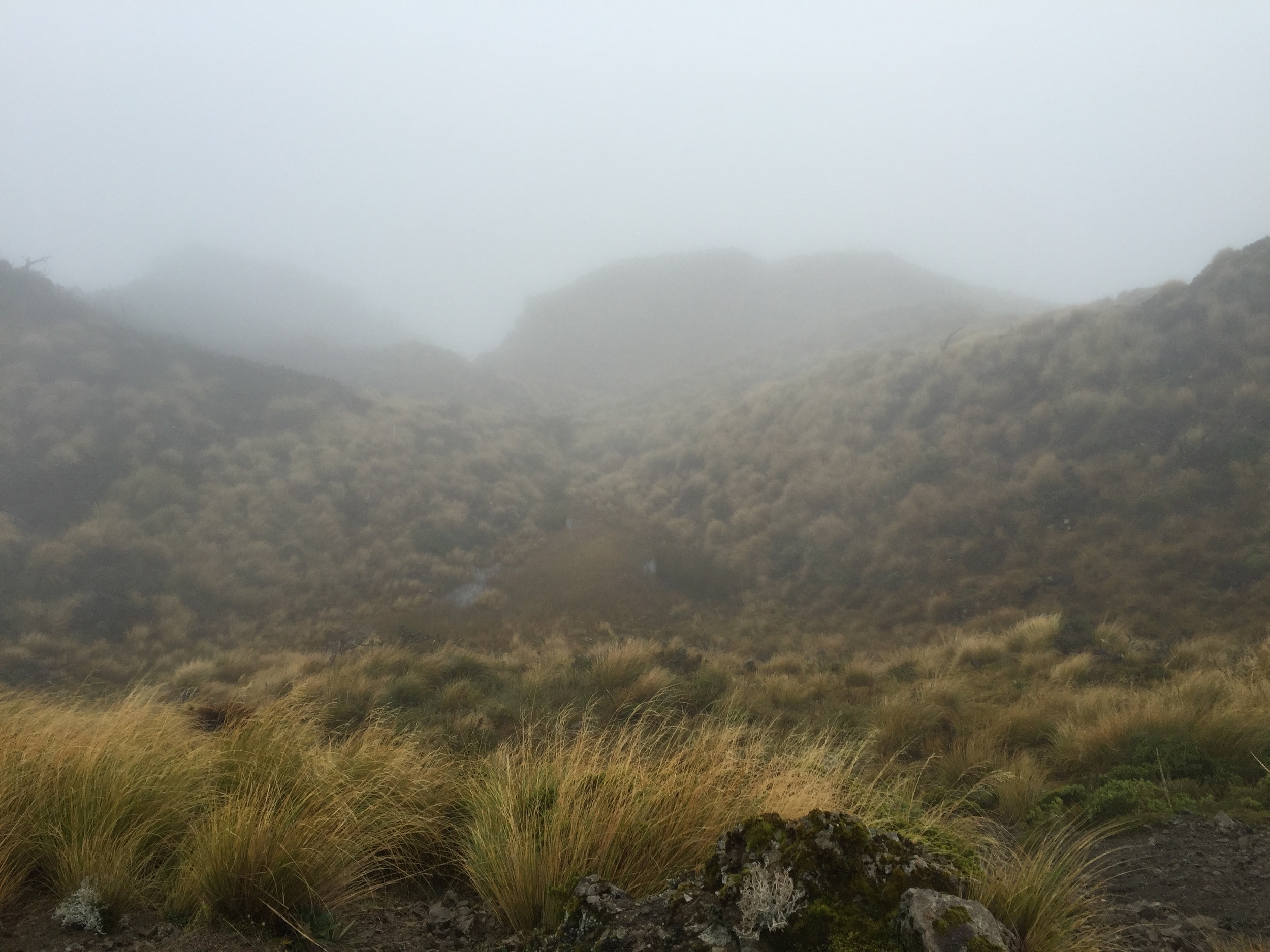
It was tough going. There were loose rocks, and where there weren’t loose rocks the spiky plants snagged at my clothing and scratched me. Visibility was getting worse and worse. It wasn’t windy, but it was foggy. Misty. Whiteout, almost. I wasn’t totally sure I was still on the right track to the summit.
At 10:30am I sat down on a rock. I took one deep breath. And I realized that I was probably lost. I don’t think I’d quite made the summit, but I don’t think I was far off either.
Common sense prevailed (a minor victory) and I started heading down in a fairly general approximation of where I thought I should go. In the grey fog, there wasn’t really a trail and all the bushes seemed pretty identical.
Eventually I came across some unique rocks that I didn’t remember seeing on my way up. Better yet, they had a scree slope, and one of the guides I’d read said that you were supposed to go up a scree slope on the last stretch of the hike. It also wasn’t so much a slope, so much as a very narrow valley or rift, incredibly steep, and with small sharp rocks that flowed like a river when you stepped on them.
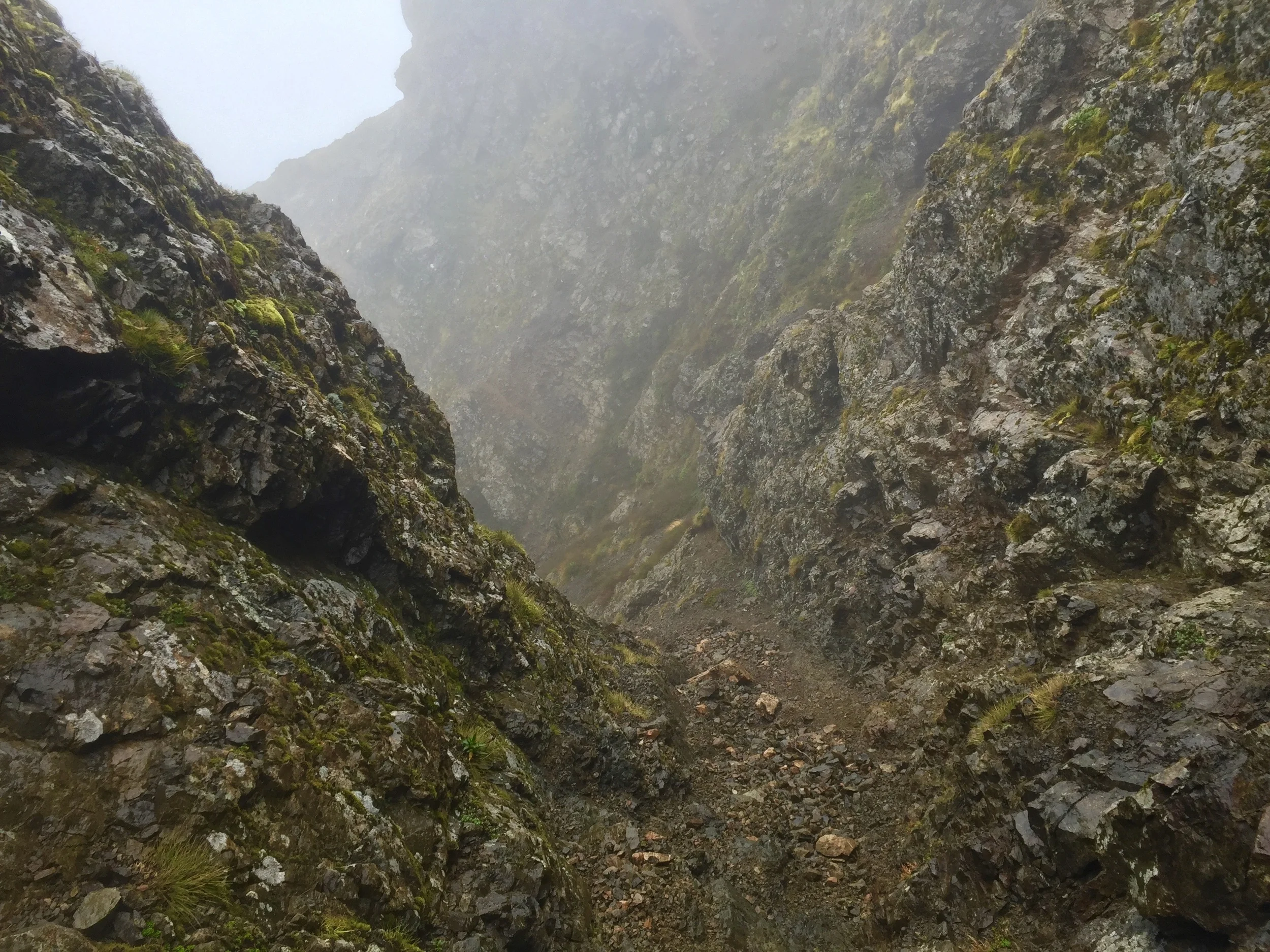
Halfway down the scree slope I realized it probably wasn’t the right one. I also realized I was in trouble. My ankles were smashed and bleeding from the rocks hitting them. It was also too steep and unstable to go upwards. I’d also ripped the ass of the Oakley shorts, but that felt like a minor worry. Like top 5, but not top 3 worries at this point. They were new shorts.
I kept going down.
The scree ended at a 15 foot cliff. Below it was another scree slope. In better conditions, I might have risked the jump. Instead, I grabbed onto some tree roots on the side of the cliff, and gradually lowered myself down. I followed this next scree slope for a little while, and it got a bit easier. The rocks became bigger, and weren’t loose. I felt like I was making good time.
I even still felt good about the conditions and the time I was making when the rocky corridor became a little bit of a mountain stream. Some of the rocks were slippery, and my feet got soaked as I stepped in the water. My shins also got banged up as I slipped on the rocks.
Within 15 minutes, I was feeling a lot worse. The stream had gotten bigger. My feet were now almost always fully submerged, and the water was cold. At least it numbed my battered shins and ankles. But I was definitely lost. Ripped shorts went way down on the worry list. Maybe top 20.
I knew that on my way to the hike, I had driven over a number of bridges across large and small streams. I thought that if I followed this one, it would eventually lead to a bigger stream that might take me to one of those bridges. From there, I could flag down a car or walk to the nearest town or something.
If only it seemed that easy. The further down I followed the stream, the denser the brush on either side got and the steeper it got. Eventually I came across a little waterfall. Like at the scree slope drop-off before, I had to climb out over the edge and use some roots and loose rocks to lower myself down.
I had to repeat this for the next waterfall, and the next. Each one was a little bit bigger, the water rushing a little bit harder.
I pulled my phone out of my bag to see if I had reception. One text message came in from a friend in New Zealand, but I didn’t have time to read it before the phone simply died. My backpack was absolutely soaked, and the phone’s screen was pretty cracked so I’m not surprised that water might have gotten in. Or that the battery was simply done.
I looked back up at where I’d come from. The stream was hidden in mist and around a corner. Ahead of me was just more of the same.
“This is it,” I said to myself. “This is how I end.”
No one knew where I was (I stupidly hadn’t thought to tell anyone where I was going). I was really far off the trail. I was in a remote place. And it was off season.
There’s a lot of things you think about at that point.
You start by thinking about how embarrassing it would be if you had to be rescued.
Then you start thinking by thinking how great it would be to be rescued.
Then you realize that no one knows where you are and your phone is dead and that you have no way of being rescued.
Then you move past that, and know that the only way you’re going to get through this is on you’re own and with what you’ve got.
So I told myself “No, this isn’t how it ends.”
I still had 5 hours of daylight. I had half a litre of water, an apple and two protein bars. I was also in the best shape of my life. I knew I could probably get through this.
I kept going. Half the time, I was walking through the stream, because the brush on the side was too thick to go through. Other times, I was scrambling down rocks and holding onto branches to get down the steeper sections. It was exhausting. But I kept going.
After an hour of this, I had a feeling I needed to head to my left, that the trail was probably over the next ridge. I left the stream and started climbing up a steep hill, pulling myself up using roots and rocks. This flattened out slightly, and I was in true rainforest again, with thick ferns and rotting logs everywhere. I followed what must have been a game trail, mostly overgrown, but switchbacking back and forth up the ridge. Back and forth.
Up ahead, near what seemed to be the top of the ridge, it looked like there was clearing. I was excited - I thought that from there, I’d be able to see out beyond the trees and get my bearings, to at least know what direction I had to head in.
When I got there, I saw that it wasn’t a clearing. It wasn’t even the top of the ridge. It was just a space where a large tree had fallen. I could see straight up and out, to the grey sky, but not to the hills or mountains around me. I was still lost. The clouds in the sky gave everything a dull, flat light. If I'd known how to navigate by the sun's position, I wouldn't have been able to.
But I kept moving. I kept pushing through the thick forest, smashing through rotten branches, until I did finally get to the top of the ridge. It was still thick, dense forest, but at least it was somewhere. And then I decided to head down the other side, half sliding and half climbing, down.
Eventually I came to another stream. On the other side of it was another steep hill, leading up to another ridge. I was too tired to climb it it. Too tired to think about pushing back up another hill for the moment. I stopped to take a drink of water - I had about 500ml left, then started down this second stream, going at it with the same strategy I approached the first: I’d follow it until it reached a bigger stream, and so on until I came to a bridge.
The difference was that this stream was deeper, but also that the trees had overgrown it a bit more so that it was a green tunnel. I had to crouch into the water to get under the branches, but even then my backpack kept getting stuck.
I couldn’t tell if I was making good time or bad time.
Compared to taking a normal hiking trail, I probably wasn’t making very good time.
Compared to anyone else who who has scrambled down a cold, rocky mountain stream, I knew I was making incredible time.
And so I kept pushing forward. Climbing down little waterfalls. Getting colder. Slipping on rocks. Smashing my shins. Always going down with the water. I could have gone past the trail at this point, I could be miles from it. There was no way to know.
Until I finally came to a bend in the stream, where the terrain flattened out and where enough trees had fallen down that I could see out of the brush. I could see a green hill, green with grass, not trees, and with sheep on it. Then I saw a fence.
I knew that it might be the sheep farm that I walked through on my way up. Even if it wasn’t, I knew that where there were sheep there was a fence. Where there was a fence, there would eventually be a gate. And where there was a gate, there would be a road that would take me…at least somewhere. Out of this forest. Out of the mountains.
I had to climb up a steep hill to get the fence, and without trees holding moisture in at this part the ground was dry, and half the rocks I tried to hold onto pulled out of the dirt and tumbled down past me into the stream.
But I made it to the fence. And I followed it until I found a road. And the road let me back to the original road I’d started on.
I had about 8km to walk back to my car from this point. I took a moment to drink some water. I ate a granola bar. And I started walking down the path.
Compared to the terrain I'd been on, it was easy going. It even seemed like the sheep on the roadside were smiling at me, and the sun even came out a bit.
I'd made it.
++++++++++++++++++++++++++++++++++++++++++++++
Mount Hikurangi Trail Review
Rating: 4/5
Notes: Beautiful hike with interesting scenery. Trail poorly marked.