
MAUI NO KA OI

Maui is the best place in the world.
Every year for the past 10 or 15 years, I've been lucky enough to spend a month or more on Maui. Arriving on the island feels like coming home. As soon as you step off the plane, you can smell the flowers and feel the humid air. If you fly in during the day, you can get a pretty good idea of what the waves will be like as the plane banks over the north side of the island.
Below are a few of my favourite places, with some links to where to find them on Google Maps.
Honolua Bay
Honolua Bay used to be one of my favourite spots to surf. First of all, the location is beautiful: after driving down long, winding coastal roads, you come across a lookout point and can see across the bay. If there are cars on the cliff across from you, it means the waves are breaking. Get back on the road, and follow it until you get to the cliff turn off. It's definitely worth hanging out there, and watching surfers from the cliff. Or climbing down the trail to go for a swim and snorkel (only do this if there aren't surfers in the water - sometimes it can look super calm, but is really just a lull between sets).
If you're in that area, it's also worth checking out DT Fleming Beach. It's a bit better for chilling on than Honolua Bay (more sand) and also has a lifeguard.
Also in the area is Slaughterhouse Beach. I'm not sure it's really surfable, but it's definitely quieter than the other beaches and worth walking down the stairs to check out.
DT Flemming Beach on Google Maps
Slaughterhouse Beach on Google Maps
Waihee Ridge Trail
View from the Waihee Ridge Trail - the area on the coast to the right is Kahului (where the airport is) and further down the coast (in the distance in pic) is Paia.
If you were to continue driving past Honolua Bay for an hour, around the Northwest side of the island, you'd eventually get to the start of the Waihee Ridge Trail. The pros of that drive are a lot of beautiful valleys and views. The cons are tons and tons of switchbacks and narrow (but drivable) roads. The Waihee Ridge Trail itself isn't super hard - probably about 8km round trip, but goes through some dense jungle, then along a ridge with beautiful views (weather permitting). From the end of the trail, you can look Eastward along the coast.
Waihee Ridge Trail on Google Maps
Paia and Hookipa
To continue the tour around the island, you could keep going from Waihee Ridge trail through Kahului and you'll end up at Paia. It's a small, little town that is half surfers and hippies and half tourists.
While you're headed that way, check out Baby Beach. It's a massive, long white beach that is perfect for walking on and there is also a nice little swimming area.
Past Paia is a beach called Hookipa - it typically has lots of surfers, but if there are no waves it might be good for swimming.
If you're in Paia try eating at the Flatbread Company.
Bamboo Forest Hike
A little bit past Paia - on the road to Hana - is a great little hike through a bamboo forest. There are streams, there are waterfalls. There is bamboo. Read the write-up here.
Haleakala - House of the Sun
Near the beginning of the Haleakala Trail.
If you go to Maui and don't do this hike I'm going to be annoyed. The deal is that you have to drive all the way to the top of Haleakala, which is the main volcanic crater on Maui. The summit is around 10,000 feet, and you'll park your car there. From there, you'll hike down into the crater and it will seem like you're on a different planet. Once you're one the floor of the crater, you'll hike around a bit, then back up out of the crater along a series of switch-backs. You'll eventually arrive at a parking lot, and from here you can easily hitchhike back to where your car is. The total trail is around 19km long, and it took me about 4 hours. Plan for 6, and bring warm clothing (including a rain jacket!), good walking shoes, food and lots of water. The weather can change quickly up there.
You can read my blog post about it from a few years ago here.
Haleakala Summit (Start of Hike) on Google Maps
Read this and find out the weather conditions before you do the hike.
South Maui (Kihei, Wailea, Makena)

The view from Keawakapu Beach.
The South side of Maui is mostly desert. It's dry. It rarely rains. And it would be totally desolate except that this is the area where most of the resorts are, so they bring the water and turn the area into a lush oasis. Kihei, Wailea and Makena are in this area.
Definitely check out Keawakapu Beach - it's a massive, long white-sand beach, and this time of year the water there should be perfect for swimming. You can walk along it, and it will take you to a path that goes in front of all the big hotels - some of them would be good to stop in for a drink. The Andaz hotel in particular has a great pool bar - perfect for watching the sunset or an afternoon swim and cocktail. In the winter months, there generally aren't any waves on this side of the island.
Further past the hotels, and you'll eventually get to Makena Beach, which is also worth checking out. A little bit further away from any development, it's definitely got a different mood than the other beaches. Also the sand is super hot there. And be careful of the shore break. But the food trucks there are generally pretty good (but might be cash only).
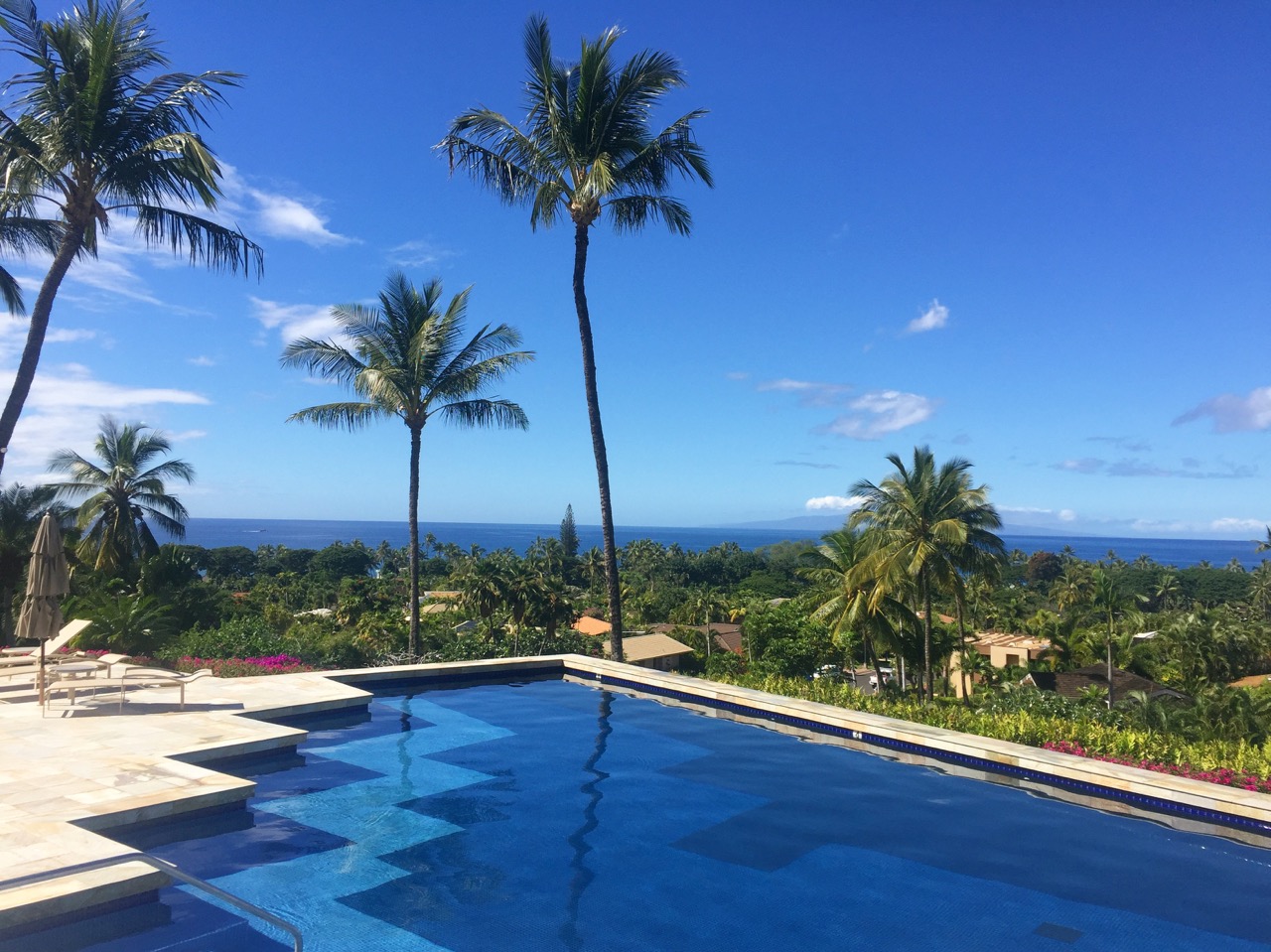
Obligatory Wailea pool photo.
The King's Highway Trail
The King's Highway
Keep going past Makena Beach (about 5km) and you'll get to La Perouse Bay and the King's Highway Trail. It's an absolutely surreal hike. After about 40 minutes of hiking along the water underneath trees and along the beach (there will be people camping and fishing there), the trail goes inland and the landscape is nothing but black and red lava rock. It's an in and out hike - no loop. The most fascinating thing is that this an ancient trail that was used by the king's tax collectors way back in the day.
Windmills Hike
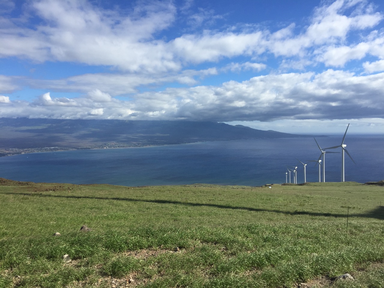
View from the Windmills
On the Southwest corner of Maui, on the road to Lahaina is the Windmills Hike, also known as the Lahaina Pali Trail. Park your car at the trailhead (Google Map link below) and follow the trail as it climbs steadily up, winding in and out of valleys. The best time to do it is the afternoon of a clear day, as it will let you look clear across the island. It should take you about 2.5 hours round trip (but bring water and good shoes). Turn back when you actually reach the windmills.
Lahaina Pali Trailhead on Google Maps
Other Stuff
DO: Visit Maui Brewing Company in Kihei. They've got good beer.
DON'T: Visit Lahaina, except to drive through on your way to other spots. It's just a big tourist trap.
DO: Check out local businesses and grocery stores. They'll often have the best food and fish. Even the grocery stores have great poke.
DON'T: Touch the sea turtles. It's illegal and you can get a sort of weird herpes.
DO: Bring a cooler to drink beer on the beach. I think it's illegal but no one really checks.
DON'T: Go off trail on hikes. It can be easy to get lost.
DO: Go to Maui Tacos. It's a chain. There are a bunch of them. And get the fish tacos and put the pineapple salsa on them.
DON'T: Bother going snorkelling. Or maybe do. I don't like snorkelling, but lots of people do and Maui is supposed to be amazing for it.
DO: Rent paddle boards, but talk to the guy about the prevailing wind and current so you don't get messed up on the way back. You'll see a lot of sea turtles from the boards. And cool coral.

The West Maui Mountains - on the road to Lahaina.